


伴随遥感影像大数据时代的到来[10]和计算机视觉的发展,深度学习方法被迅速引入到遥感影像建筑物提取应用中,许多成熟的算法,如Unet[11]、ResNet[12]、HRNet[13]等都取得了较好的结果。在此基础上,一些研究人员还在后处理过程中结合多源数据[14−15]、多层训练样本[16]等方式来提高建筑物提取的效果。但是,这些模型受卷积核大小与感受野范围的限制,缺乏对整体特征的提取能力,且上下文空间关系建模不足。目前,计算机视觉领域中的Transformer结构[17]因其具有强大的全局建模能力,可以建立长距离的特征依赖,受到了遥感领域广大研究者的关注,但纯粹的Transformer结构消耗计算资源巨大,且容易忽略空间细节丰富的浅层特征信息及局部信息,造成建筑物边缘像素和小目标对象丢失。
结合遥感影像建筑物类间差异小,尺度不一、复杂性高等特点,并针对当前大部分深度学习算法对影像全局特征建模不足、边缘细节丢失等问题,提出了一种结合边缘增强的全局自注意力遥感建筑物提取网络E−GSANet,在增强建筑物边缘的同时,获取特征的全局上下文语义,同时采用逐级上采样解码,兼顾不同尺度建筑物的完整性和准确性,提升遥感影像的建筑物提取精度。
1 研究方法
1.1 网络整体架构
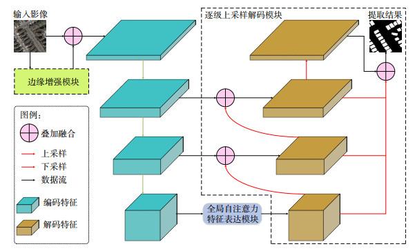
在基于遥感影像的深度学习建筑物提取网络中,浅层特征包含丰富的建筑物空间细节,深层特征包含高阶的语义信息。卷积神经网络可以实现从浅层到深层逐步提取特征,但在线性传递过程中,容易丢失边缘细粒信息;且网络感受野受卷积核大小固定的限制,缺乏提取全局上下文信息的能力,长距离空间关系建模不足;此外,多数网络直接将深层特征解码为预测图,容易丢失大量空间细节。针对这些问题,提出了嵌入遥感边缘先验特征,顾及全局上下文语义,高、低层次信息融合互补解码的E−GSANet。
网络整体架构如图 1所示,在改进的ResNet50[12]主干上,添加边缘增强模块,全局自注意力特征表达模块和逐级上采样解码模块。首先,将公开数据集的训练子集影像采样为256×256大小,在编码前,首先,使用边缘增强模块对建筑物边界信息显式提取,捕获边缘先验信息与原始影像叠加融合,输入主干网络进行特征编码,线性地获取并传递浅层空间细节与深层高阶语义;其次,将富含高阶语义信息的深层特征映射为一组序列向量,使用全局自注意力特征表达模块实现长距离特征依赖关系与多层次边缘增强特征的融合表达,学习并建模全局上下文语义信息;再次,使用逐级上采样的方式对增强后的特征进行解码,通过跃层连接的方式与富含空间细节的低阶编码特征融合并输出阶段性预测结果;最后,聚集所有的阶段性预测结果,实现特征对象间信息的传递与继承,生成精细边缘的遥感影像建筑物提取结果。
1.2 边缘增强模块
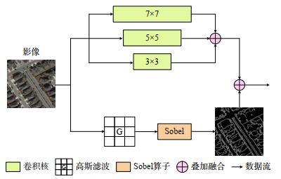
卷积数据流由3个大小为7×7、5×5和3×3的并行卷积组成,对于输入的原始影像,首先执行3次卷积操作获取不同感受野的多尺度特征,并通过设置相应的零填充与采样步长,保持特征图大小一致,然后使用通道叠加实现特征通道间的信息聚合。该过程可以表示为
式中,Fi为卷积后得到的特征图,i=1, 2, 3, Conv2i+1为核大小为2i+1的卷积操作,Image为输入影像,Concat表示特征通道叠加操作,Ffinal表示卷积数据流最后的输出特征。
边缘提取数据流的主要设计思路是通过捕获建筑物和背景之间的灰度值突变以凸出边缘显著信息,使用Canny算法实现,具体步骤包括高斯滤波去噪和Sobel算子找寻梯度,高斯滤波可以对图像进行平滑去噪处理,Sobel算子求每个像素点梯度的幅值和方向,经过非极大值抑制和弱边缘舍弃后,得到最终的边缘提取结果。高斯滤波器和像素梯度计算可以用以下公式表示
式中,G为二维高斯函数经过采样以及归一化之后得到的高斯滤波器,x、y为像素位置,g为梯度的模,θ表示梯度的方向。
1.3 全局自注意力特征表达模块
全局自注意力特征表达模块主要依靠Transformer机制实现,它打破了卷积神经网络中局部感受野的限制,通过自注意力建模边缘增强特征的长距离依赖关系并为其赋予全局上下文信息。
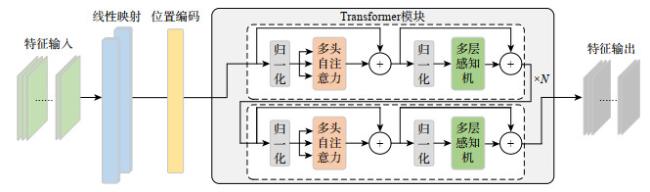
式中,Vin、Vmid和Vout分别为Transformer编码模块的输入向量、中间向量和输出向量,Fin、Vpos是全局自注意力特征表达模块中的输入特征和位置编码向量,Flat(·)、MSA(·),MLP(·)、LN(·)为展平、多头注意力、多层感知机和层归一化操作。
1.4 逐级上采样解码模块
在ResNet等网络中,直接将最深层特征解码的方式极易丢失空间信息细节。为此,受UNet[11]结构启发,设计了一种改进的逐级上采样解码模块,架构如 图 1所示。在解码过程中,将被赋予了全局上下文交互信息的特征通过逐层级的双线性插值上采样方法,在保证计算速度的同时获取较好的插值效果,渐进地恢复为与主干网络对应阶段编码特征相同的大小,与富含空间细节的同阶编码特征通过跃层连接的方式叠加融合,同时输出阶段性预测结果;逐层重复此操作,最后,叠加融合所有的阶段性预测结果并输出。通过这种逐级上采样解码的方式,将深层特征的高阶语义信息与浅层特征的丰富空间细节相结合,实现特征对象间信息的高效融合与恢复,准确提取建筑物边界,得到高精度的预测结果。
2 实验过程
2.1 数据集介绍
本文采用2个公开的遥感影像建筑物数据集对各提取方法进行对比与测试。WHU建筑物数据集[20]对各个建筑物提取方法进行对比与测试(https://study.rsgis.whu.edu.cn/pages/download/building_dataset.html)。该数据集是目前国际上范围最大、标注精度最高的遥感影像建筑物公开数据集,能够很好地验证不同建筑物提取方法的性能和鲁棒性。数据来自新西兰土地信息服务网站,涵盖了新西兰基督城(Christchurch, New Zealand)中村庄、住宅、商业区、工业区等不同场景下18.7万座建筑物,共计8188张影像,大小为512×512像素,空间分辨率为0.3 m,包含红、绿、蓝3个波段。在数据集中,官方划分4736张影像为训练集,1036张影像为验证集,2416张影像为测试集。顾及当前计算机硬件图形处理器的性能,将数据集中每张影像无重叠地裁剪成256×256大小的切片。INRIA建筑物数据集[21](https://project.inria.fr/aerialimagelabeling)由法国国家信息与自动化研究所提供,涵盖不同国家的5个城市地区,建筑密度、风格、排列各不相同,数据类型具有多样性,可以验证各方法的泛化能力。数据集空间分辨率为0.3 m,包括红、绿、蓝3个波段。本文将每张影像不重叠分割,得到18000张500×500大小的标签影像,设置训练子集和验证子集的比例为8∶2。
2.2 实验环境与训练细节
模型代码基于Pytorch框架实现。所有的实验都是在一台配备Intel(R) Xeon(R) CPU E5−2686 v4 CPU(2.30 GHz),操作系统为Ubuntu18.04的服务器上运行,使用一块NVIDIA GeForce RTX 3090图形处理器(24 G内存)进行训练和测试。
在网络训练的每一个批次过程中,实验将每个影像随机进行水平翻转与正负15°之间的旋转,提高模型对数据的泛化能力,避免网络的过拟合。其次,选择混合的交叉熵损失和Dice损失[22]作为目标函数,使用AdamW方法进行模型优化,设置初始学习率为0.002,权值衰减为1×10⁻⁴。训练数据的批次大小设置为8。
2.3 评价指标
采用当前遥感建筑物提取任务中最常见的评价指标来定量评估本文的网络性能,包括准确率(P)、召回率(R)、F1−score(F1)、交并比(IoU)和总体像素精度(OA)。具体计算如下
其中,TP(true positive)为正确预测的建筑物像素数;TN(true negative)为正确预测的非建筑物像素数;FP(false positive)为错误预测为建筑物的像素数,即错检;FN(false negative)表示错误预测为非建筑物的像素数,即漏检。
P为正确预测的建筑物像素数与所有预测为建筑物的像素数比值;R为正确预测的建筑物像素数与真实建筑物的像素数比值;F1是对P和R的调和参数平均;IoU是真实建筑物区域和预测建筑物区域交集和并集的比值,OA代表了所有正确预测的整体像素精度。
3 结果与分析
3.1 对比实验分析
表1 不同方法的对比结果 |
| 方法 | P/% | R/% | F1/% | IoU/% | OA/% |
| UNet* | 92.62 | 93.50 | 93.06 | 87.02 | 98.47 |
| PSPNet* | 93.41 | 91.95 | 92.68 | 86.35 | 98.40 |
| DANet* | 94.01 | 89.71 | 91.81 | 84.86 | 98.24 |
| PAN* | 92.80 | 91.49 | 92.14 | 85.43 | 98.28 |
| MA-FCN | 94.50 | 94.20 | 94.30 | 89.50 | — |
| SRI-Net | 95.21 | 93.28 | 94.23 | 89.09 | — |
| HCRB-MSAN | 96.78 | 94.68 | 95.72 | 91.79 | 99.07 |
| E-GSANet | 96.82 | 95.00 | 95.90 | 92.13 | 99.11 |
注:*表示没有提供精度结果的算法,使用官方或开源代码复现算法并得到了相应的测试结果。 |
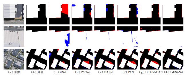
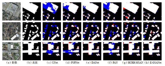
从测试集中选取了3组典型类型的建筑物来对比其他方法与E−GSANet定性可视化结果的差异,包括易混淆地物(第1行),大尺度建筑物(第2行)和密集小尺度建筑物(第3行)。如图 4所示,为了直观显示,使用红色表示错检,蓝色表示漏检。在第1行中,UNet没有正确区分建筑物与相似路面的差异,其他方法在建筑物不规则突起和右侧边缘存在一定漏检和错检;在第2行大尺度建筑物影像中,与E−GSANet相比,其他方法出现了内部缺失和外部轮廓不清晰的现象;同样,在第3行密集小尺度建筑物中,本文方法可以获得较为精确的提取结果,很少有差异区域。从视觉表现来看,得益于边缘增强、全局自注意力特征表达和逐级上采样解码,E−GSANet较好地保持了各类建筑物的边缘准确性、整体一致性和空间细节。
表 2展示了各方法在INRIA测试子集上的定量评估结果,E−GSANet在R、F1、IoU和OA这4项指标上得到了最优的结果,分别为89.87%、89.06%、80.28%、97.02%。同时,网络在取得具有竞争力的P和R指标之外,也保持了这两个指标的高度一致性。取得最优P值的PAN方法,与对应的R相差13.09%,这种P与R之间的巨大差异,一定程度上反映了网络性能的失衡,无法鲁棒地对建筑物进行准确提取。
表2 INRIA建筑物数据集上不同方法的对比结果 |
| 方法 | P/% | R/% | F1/% | IoU/% | OA/% |
| UNet* | 82.73 | 80.09 | 81.39 | 68.61 | 95.06 |
| PSPNet* | 81.63 | 86.55 | 84.02 | 72.45 | 95.56 |
| DANet* | 82.66 | 84.37 | 83.51 | 71.68 | 95.51 |
| PAN* | 90.11 | 77.02 | 83.05 | 71.02 | 95.76 |
| FPCRF | — | — | 87.65 | 74.79 | 95.81 |
| SRI-Net | 85.77 | 81.46 | 83.56 | 71.76 | — |
| HCRB-MSAN | 89.56 | 88.13 | 88.84 | 79.92 | 97.01 |
| E-GSANet | 88.26 | 89.87 | 89.06 | 80.28 | 97.02 |
注:*表示没有提供精度结果的算法,使用官方或开源代码复现算法并得到了相应的测试结果。 |
3.2 消融实验分析
为了验证E−GSANet中3个模块的效果,进行了一系列的消融实验。结果如表 3所示,当不添加任何模块,仅使用主干网络时,可以获得92.25% 的F1和85.62% 的IoU指标值;以此作为基线,当增加逐级上采样解码模块时,效果增益显著,F1和IoU分别提升了2.7% 和4.77%;在此基础上添加全局自注意力特征表达模块,网络性能得到进一步的增强,相比仅使用逐级上采样解码模块,F1增加了0.39%,IoU增加了0.71%;最后,网络集成3个模块,各项指标都达到了最优的结果,其精度结果相较于基线方法有明显的改善。实验结果表明,边缘增强模块、全局自注意力特征表达模块和逐级上采样解码模块可以有效提高建筑物特征的提取效果,增益网络性能。
表3 E−GSANet各模块的消融实验结果 |
| 边缘增强模块 | 全局自注意力特征表达模块 | 逐级上采样解码模块 | P/% | R/% | F1/% | IoU/% | OA/% |
| — | — | — | 91.43 | 93.09 | 92.25 | 85.62 | 98.28 |
| — | — | √ | 94.98 | 94.93 | 94.95 | 90.39 | 98.89 |
| — | √ | √ | 95.81 | 94.88 | 95.34 | 91.10 | 98.98 |
| √ | √ | √ | 96.82 | 95.00 | 95.90 | 92.13 | 99.11 |
4 结论
针对现有遥感影像建筑物提取深度学习算法的全局特征建模不足、边缘细节丢失等问题,提出了嵌入遥感边缘先验特征,顾及全局上下文语义,高、低层次信息融合互补解码的遥感建筑物提取网络E− GSANet。网络包含3个模块,边缘增强模块可以对建筑物边界信息显式提取,挖掘遥感影像内在知识先验,引导网络充分利用边缘显著特征;全局自注意力特征表达模块使用Transformer机制,建模边缘增强特征的长距离依赖关系,捕获全局上下文信息;逐级上采样解码模块可以实现特征对象间信息的高效融合与恢复,准确提取建筑物边界。在WHU建筑物数据集上进行了大量且详尽的实验与分析,实验分析证明,与列举的其他方法相比,E−GSANet能够取得最佳的遥感影像建筑物提取结果,这可以为城市精细化管理,土地资源调查等应用提供一定的支持。
在未来的工作中,计划探寻一种轻量化方法,在减少对计算硬件消耗的前提下,降低参数量的同时保持提取精度,使模型更适合于实际生产任务;此外,还将尝试迁移该模型至多类别提取任务,验证方法的泛化能力,并研究遥感影像中城市多类别地物的高效及高精度提取工作。


