Global self-attention remote sensing building extraction networkcombined with edge enhancement

Expand
  • 1. College of Resource Environment and Tourism, Capital Normal University, Beijing 100048, China

    2. Beijing Geo-Vision Information Technology Co., Ltd., Beijing 100070, China

    3. Aerospace Information Research Institute, Chinese Academy of Sciences, Beijing 100094, China

    4. Beijing Polytechnic College,Beijing 100144,China

    5. North China University of Water Resources and Electric Power, Zhengzhou 450045, China

    6. Zhongguancun Smart City Co., Ltd., Beijing 100081, China

Received date: 2024-01-03

  Revised date: 2024-09-26

  Online published: 2025-01-07

Abstract

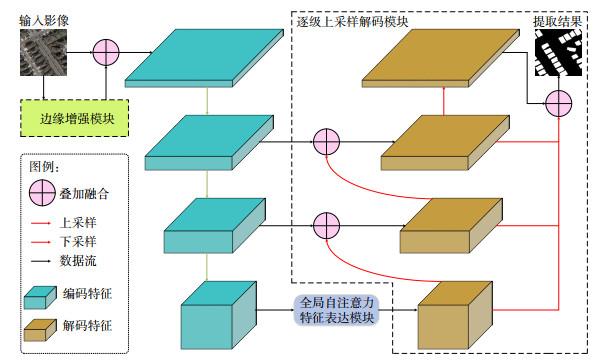
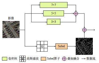
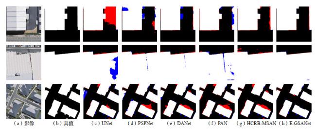
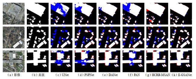
The accurate and efficient extraction of building from remote sensing images is fundamental for applications such as fine urban management, high-precision mapping, and land resource investigation. It is essential to investigate how to leverage image features for intelligent interpretation. This study introduces a global self-attention network with edge-enhancement (EGSANet) for remote sensing building extraction. The network integrate the edge enhancement module into the encoder backbone,providing the network with a priori knowledge about boundaries, and then establish long-distance dependency relationships between features using the global self-attention feature expression module, enabling the fusion of salient features with edge enhanced features. A stepwise up-sampling decoding module is designed to fusing the shallow features with rich spatial detail information and the deep features with high-order semantic information to obtain accurate extraction results of buildings. The comparison experiments between E-GSANet and the current mainstream methods is conducted based on two open-source remote sensing building datasets. The quantitative analysis and qualitative demonstrations prove that E-GSANet achieves optimal result sacross all evaluation metrics, yielding more complete building extractions, precise edges, and higher accuracy. Additionally,network structure ablation experiments and analysis demonstrate the effectiveness of each module.

Cite this article

LI Zhen1, ZHANG Zhenxin, WANG Tao, PENG Xueli, YUE Guijie, ZHANG Deyu, LIU Xianlin2, LI Jianhua . Global self-attention remote sensing building extraction networkcombined with edge enhancement[J]. Science & Technology Review, 0 : 1 . DOI: 10.3981/j.issn.1000-7857.2024.01.00025

References

[1] Li D R, Wang M, Jiang J. China's high-resolution optical remote sensing satellites and their mapping applications[J]. Geo-spatial Information Science, 2021, 24(1): 85-94.

[2] 龚健雅, 张展, 贾浩巍, 等. 面向多源数据地物提取的遥感知识感知与多尺度特征融合网络[J]. 武汉大学学报(信息科学版), 2022, 47(10): 1546-1554.

[3] Hu S G, Wang L. Automated urban land-use classification with remote sensing[J]. International Journal of Re⁃mote Sensing, 2013, 34(3): 790-803.

[4] Ural S, Hussain E, Shan J. Building population mapping with aerial imagery and GIS data[J]. International Journal of Applied Earth Observation and Geoinformation, 2011,13(6): 841-852.

[5] Goetz S J, Smith A J, Jantz C, et al. Monitoring and predicting urban land use change[C]//Proc. IEEE International, Geoscience and Remote Sensing Symposium,IGARSS’03. Toulouse, France: IEEE, 2003, 3: 1567-1569.

[6] Peng J, Liu Y C. Model and context-driven building extraction in dense urban aerial images[J]. International Journal of Remote Sensing, 2005, 26(7): 1289-1307.

[7] Inglada J. Automatic recognition of man-made objects in high resolution optical remote sensing images by SVM classification of geometric image features[J]. ISPRS Journal of Photogrammetry and Remote Sensing, 2007, 62(3):236-248.

[8] Cetin M, Halici U, Aytekin Ö. Building detection in satellite images by textural features and Adaboost[C]//Proceedings of IAPR Workshop on Pattern Recognition in Re⁃mote Sensing. Piscataway, NJ: IEEE, 2010: 1-4.

[9] Li E, Femiani J, Xu S B, et al. Robust rooftop extraction from visible band images using higher order CRF[J].IEEE Transactions on Geoscience and Remote Sensing,2015, 53(8): 4483-4495.

[10] Zhang B, Chen Z C, Peng D L, et al. Remotely sensed big data: Evolution in model development for information extraction[point of view[J]. Proceedings of the IEEE,2019, 107(12): 2294-2301.

[11] Ronneberger O, Fischer P, Brox T. U-net: Convolutional networks for biomedical image segmentation[M]//Lecture Notes in Computer Science. Cham: Springer International Publishing, 2015: 234-241.

[12] He K M, Zhang X Y, Ren S Q, et al. Deep residual learning for image recognition[C]//Proceedings of IEEE Conference on Computer Vision and Pattern Recognition(CVPR). Piscataway, NJ: IEEE, 2016: 770-778.

[13] Sun K, Xiao B, Liu D, et al. Deep high-resolution representation learning for human pose estimation[C]//Proceedings of IEEE/CVF Conference on Computer Vision and Pattern Recognition (CVPR). Piscataway, NJ: IEEE,2019: 5686-5696.

[14] Bittner K, Adam F, Cui S Y, et al. Building footprint ex⁃traction from VHR remote sensing images combined with normalized DSMs using fused fully convolutional networks[J]. IEEE Journal of Selected Topics in Applied Earth Observations and Remote Sensing, 2018, 11(8):2615-2629.

[15] Cao Z Y, Fu K, Lu X D, et al. End-to-end DSM fusion networks for semantic segmentation in high-resolution aerial images[J]. IEEE Geoscience and Remote Sensing Letters, 2019, 16(11): 1766-1770.

[16] Liu Y B, Zhang Z X, Zhong R F, et al. Multilevel building detection framework in remote sensing images based on convolutional neural networks[J]. IEEE Journal of Selected Topics in Applied Earth Observations and Remote Sensing, 2018, 11(10): 3688-3700.

[17] Dosovitskiy A, Beyer L, Kolesnikov A, et al. An image is worth 16x16 words: Transformers for image recognition at scale[EB/OL]. [2023-12-23]. http://arxiv.org/abs/2010.11929

[18] Canny J. A computational approach to edge detection[J].IEEE Transactions on Pattern Analysis and Machine Intelligence, 1986, PAMI-8(6): 679-698.

[19] Ba J L, Kiros J R, Hinton G E. Layer normalization[EB/OL]. [2023-12-23]. https://arxiv.org/abs/1607.06450v1

[20] Ji S P, Wei S Q, Lu M. Fully convolutional networks for multisource building extraction from an open aerial and satellite imagery data set[J]. IEEE Transactions on Geoscience and Remote Sensing, 2019, 57(1): 574-586.[21] Maggiori E, Tarabalka Y, Charpiat G, et al. Can semantic labeling methods generalize to any city? the inria aerial image labeling benchmark[C]//Proceedings of IEEE International Geoscience and Remote Sensing Symposium (IGARSS). Piscataway, NJ: IEEE, 2017: 3226-3229.

[22] Milletari F, Navab N, Ahmadi S A. V-net: Fully convolutional neural networks for volumetric medical image segmentation[EB/OL]. [2023-12-23]. https://arxiv. org/abs/1606.04797v1

[23] Zhao H S, Shi J P, Qi X J, et al. Pyramid scene parsing network[C]//Proceedings of IEEE Conference on Computer Vision and Pattern Recognition (CVPR). Piscataway,NJ: IEEE, 2017: 6230-6239.

[24] Fu J, Liu J, Tian H J, et al. Dual attention network for scene segmentation[C]//Proceedings of IEEE/CVF Conference on Computer Vision and Pattern Recognition(CVPR). Piscataway, NJ: IEEE, 2019: 3141-3149.

[25] Li H C, Xiong P F, An J, et al. Pyramid attention network for semantic segmentation[EB/OL]. [2023-12-23].https://arxiv.org/abs/1805.10180v3

[26] Wei S Q, Ji S P, Lu M. Toward automatic building footprint delineation from aerial images using CNN and regularization[J]. IEEE Transactions on Geoscience and Re⁃mote Sensing, 2020, 58(3): 2178-2189.

[27] Liu P H, Liu X P, Liu M X, et al. Building footprint extraction from high-resolution images via spatial residual inception convolutional neural network[J]. Remote Sensing, 2019, 11(7): 830.

[28] Li Q Y, Shi Y L, Huang X, et al. Building footprint generation by integrating convolution neural network with feature pairwise conditional random field (FPCRF) [J].IEEE Transactions on Geoscience and Remote Sensing,2020, 58(11): 7502-7519.[29] Li Z, Zhang Z X, Chen D, et al. HCRB-MSAN: Horizontally connected residual blocks-based multiscale attention network for semantic segmentation of buildings in HSR remote sensing images[J]. IEEE Journal of Selected Topics in Applied Earth Observations and Remote Sensing, 2022, 15: 5534-5544.

Outlines

/